
MONITOR - Topographic Survey Monitoring
The “Monitor” software allows comparison between multiple topographic surveys of the same object carried out at different times in order to monitor the temporal evolution of the surveyed points.
Try it now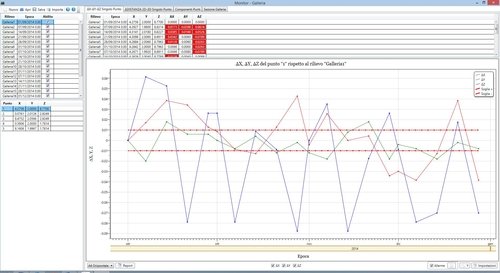
Features
- Import of survey coordinates using the most common instrument formats. Import from CIVIL Design LLL files and ASCII format.
- Saving and opening projects containing multiple previously imported surveys.
- Tabular display of surveys, points of each survey, and fully dynamic tabular and graphical calculation results.
- Possibility to exclude one or more surveys from the analyses
Analyses and comparisons
- Possibility of various types of analysis and comparison:
- Variation of the three components X, Y, and Z of a single point among the various surveys
- Variation of 2D and 3D distances of a single point among the various surveys
- Displacement velocity of the single point
- Trend of the individual X, Y, and Z components of one or more user-selected points
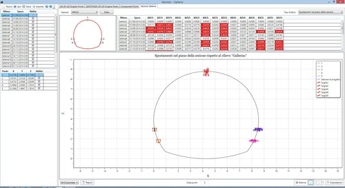
- Displacements in the X–Y plane (planimetric)
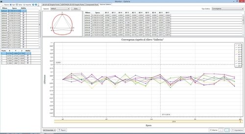
- Analysis related to a tunnel section:
- Displacements in the section plane
- Transverse displacements
- Longitudinal displacements
- Vertical displacements
- Convergence
- Convergence velocity
Alerts and Reports
- Possibility to set an alarm using a threshold value and the related graphical and tabular representation of exceedances
- Automatic reporting in RTF format
- Customizable graphical settings
Requirements
Installation requirements
-
Microsoft® operating systems: Windows® 11, 10.
-
Requires at least .NET Framework 3.5 to be installed
