
Epa GIS
This software allows you to convert an EPANET or EPA-SWMM INP file into various Shape files that can be imported into a GIS environment. From there, modifications can be made and the source files can then be updated.
Try it now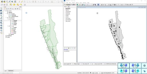
Features
- Conversion of EPANET INP file into shape GIS format.
- Conversion of SWMM INP file into shape GIS format.
- Export of EPANET or SWMM RTP results file data into shape elements.
- Creation or update of SWMM INP file from shape GIS format.
- Creation or update of EPANET INP file from shape GIS format.
- Possibility to create a QGIS project file during GIS conversion.
- Possibility to drag and drop the INP file for quick OPEN or RUN actions.
* The software is available in English only
Requirements
-
Windows® 11 or 10, 64-bit
-
EPANET data processed by the program (TITLE, JUNCTIONS, RESERVOIRS, TANKS, PIPES, PUMPS, VALVES, TAGS, STATUS, PATTERNS, CURVES, EMITTERS, TIMES, OPTIONS, COORDINATES, VERTICES, BACKDROPS)
-
SWMM data processed by the program (TITLE, OPTIONS, RAINGAGES, SUBCATCHMENTS, SUBAREAS, INFILTRATION, JUNCTIONS, OUTFALLS, DIVIDERS YES, STORAGES, CONDUITS, PUMPS, ORIFICES, WEIRS, OUTLETS, XSECTIONS, TRANSECTS, LOSSES, CURVES, TIMESERIES, COORDINATES, VERTICES, POLYGONS, SYMBOLS)
